
The text of the tour in English
Belozersk Kremlin Tour
Dear guests,
We are glad to welcome you to the ancient Belozersk land!
During our tour, you will get acquainted with the ancient past of our region, find out who Prince Sineus is, and hear the history of the construction of the Belozersk fortress. You will admire our large White Lake which keeps many secrets and mysteries in its depths. I hope that our journey will not leave anyone indifferent.
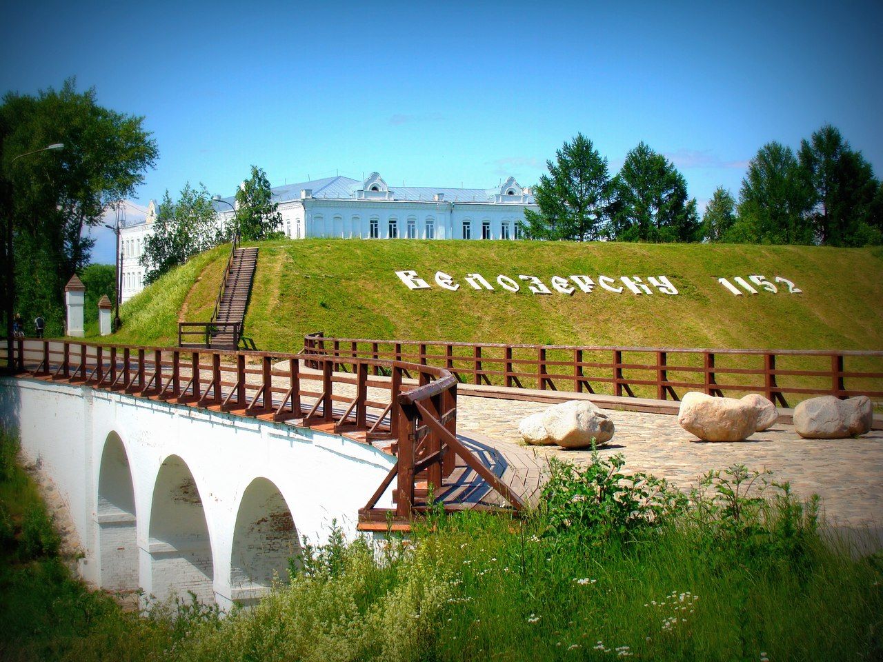
Right in front of you there is a unique defensive structure of the 15th century – Belozersk Kremlin – with its mighty earthen rampart and deep moat with a three-arched brick bridge across it. Inside the rampart you can see the Transfiguration Cathedral which gives the entire fortress monumentality and magnificence.
Now this is a kind of visit card of Belozersk. To your right you can see a wooden ship, popularly called the “Belozersk boat”, and a huge stone with the inscription carved on it: “The town of Belozersk was founded in 862”.
The modern town of Belozersk with the fortress located in its center is rightfully considered the heir to the more than thousand-year history of Beloozero. Chronicler Nestor, the author of the Tale of Bygone Years, calls Beloozero one of the territories that originally formed the core of the Old Russian state. This region was located on the border between the central regions of Russia and its northern periphery. Beloozero is both the name of the largest water body in the region (White Lake), and the name of the large historical region around it (today it is called Belozerie), and the name of the capital town of the region. But questions about the time of the founding of the town and the location of the ancient capital of Beloozero have long been the subject of debate. The fact is that the location of the capital changed, and written and archaeological sources, due to their characteristics, provide insufficient information to resolve this issue.
Beloozero is mentioned for the first time in the introductory part of the all-Russian chronicle “The Tale of Bygone Years” together with such cities as Ladoga, Novgorod, Izborsk, Rostov and others, in an article under the year of 862.
It is important to remember that this chronicle was compiled at the beginning of the 11th century, and for the early stage of Russian history it is not a chronicle itself – annual or more frequent records of events that occurred. The initial part of The Tale of Bygone Years is the result of reconstructing the chronology and even the content of the events of the most ancient period of Russian history by combining scattered early records of different origins and verbal legends. One of them was the legend about the calling of the Varangians, part of which is the mentioned chronicle article dated 862. The reliability of the early events described in The Tale of Bygone Years, and especially their chronology, is not recognized by all scientists, and remains a matter of dispute.
Some scientists consider Rurik, Sineus and Truvor to be real historical figures, while the other half of historians prove that Rurik really existed, and the names of his brothers – Sineus and Truvor – are only an incorrect translation from the ancient Swedish language of the concepts "sin hus" (his home) and "tru waring" (faithful squad).
Under these conditions, only the results of archaeological research can become a decisive argument for establishing the time of the town’s origin. The scientific basis for determining the age of a settlement can be the discovery of reliably dated cultural deposits. Of course, archaeological methods will not be able to establish the time of the emergence of a particular settlement with an accuracy of a year, but they make it possible to reliably determine the chronological boundaries of an event with an accuracy of several decades.
Based on the results of archaeological research, it can be argued that the oldest urban center of the region is a huge archaeological monument in the Old Town plot of land on the banks of the Sheksna River at its source from White Lake. The town existed here since the middle of the 10th century. The old town of Beloozero on the Sheksna River is one of the few ancient Russian towns that did not have any noticeable fortifications. Beloozero had no fortifications not only in the 10th–11th centuries (at the same time, for example, Novgorod and Staraya Russa did not have them either), but also during its golden time in the 12th–13th centuries when the town stretched along the both banks of the river for more than a kilometer. This can be explained by the fact that Beloozero was located on the periphery of the political events that shook most of the Russian principalities in the 12th–13th centuries.
The location of the town at the source of the Sheksna River was associated with greater economic benefits. The fact is that in ancient times, a trade route “from the Varangians to the Arabs” passed through White Lake, connecting the countries of the Baltic region with the Volga region and Persia. Along this waterway, merchant-warriors from Scandinavia who were called Varangians in Russia, Normans in Western Europe, and they called themselves Vikings, on approximately these boats with shields hanging on the sides, with an image of a dragon on the bow and a red and white sail, carried their goods to the distant, mysterious East. In our lands they traded more than fought, unlike the European countries where they left a bloody memory of themselves.
Founded at the intersection of trade routes, the town of Beloozero rapidly developed and grew rich. At that time, it was a large, crowded trade and craft center with wide cobbled streets, solid estates, craft workshops, piers and warehouses for goods. The Belozersk region became an independent principality in 1238. The principality did not match in size with the modern Belozersk district but was much larger, capturing modern Cherepovets, Vashkinsky, Kirillov, Vologda districts, Poshekhonye (Yaroslavl region).
The founder of the two oldest monasteries in the Vologda region – the Trinity Ust-Shekhonsky, which existed near the source of the Sheksna River from White Lake, and the island Spaso-Kamenny on Kubenskoye Lake, is considered to be the first Belozersky prince Gleb Vasilkovich. After the death of the Rostov prince Vasilko Konstantinovich in the tragic battle with the Tatars which took place on March 4, 1238 on the City River, Beloozero separated from the Rostov principality, and Vasilko’s youngest son Gleb began to reign in it from the time he came of age.
The formation of the independent Belozersk principality became evidence not only of the continuing political fragmentation of Russia but also of some changes in its economic sphere. The invasion of the Tatar-Mongols and their subsequent raids forced the population to look for safe places to live, one of which was Beloozero lost in the forests.
We will begin our acquaintance with the town with the famous earthwork. This monument of defensive architecture is one of the best in the country, and on its basis we can trace how fortresses were built in the old Russia in general.
Crossing the bridge and going up to the earthworks.
We are located on the top of the earthwork or the rampart which is the historical center of Belozersk. Try not to come close to the edge, be attentive and careful.
You may have a question: for what purpose was such an impressive fortress built? After all, Belozersk did not know external enemies until the beginning of the 17th century, and by the beginning of construction all civil strife had ceased.
And at the end of the 15th century a royal decree was issued to begin the construction. Peasants and craftsmen with axes and shovels begin to flock here from all over the area. The Tsar sent experienced architects from Moscow to supervise the construction. For the construction of the fortress, a high platform with heavy clay soil that holds water well was chosen. The stream that flowed in this place was diverted to the side. Upon completion of construction, its water was supposed to be used to fill the fortress moat.
After this, thousands of workers began to build the base of the future fortress. Large stones were transported on special drags with the help of horses, placed along the perimeter of the future fortress and covered with a layer of lake sand. Then a deep ditch was dug. You can see its remains in front of you. The earth removed from the ditch was distributed along the base of the earthwork. At the same time, logging took place in the forest to continue construction. From debarked pine and fir-tree trunks, a team of skilled woodmen made a complex frame which became the basis of the earthen rampart. The framework consisted of two parallel walls connected by transverse walls so that deep cages were obtained and filled with earth and sand. Due to this method of construction the wall was more stable and reliable. The outer side of the earthwork was covered with earth and turf. Thus, this massive structure, called the "logged earthwork", was approximately 30m high and represented a significant force.
A wooden fortress was built on top of the earthworks. The four-meter walls were interrupted by towers. There were 8 towers in total, each with its own name. The towers were quadrangular, with loopholes for arquebuses, 2 of them with gates and 6 blind. The highest of them was called the Bogoslovskaya tower. It had 3 floors and its total height was up to 9 meters. This tower was located at the place where the entrance to the Kremlin territory is now located. The fortress was connected to the settlement from the outside through the double gates of the Bogoslovskaya tower. A wooden bridge on piles was thrown across the moat. It was constructed in such a way that it could be dismantled in a short time.
After the construction of the bridge, water from a previously diverted stream was fed into the moat. It filled up to the required level, and the fortress was inaccessible from all sides.
At that time, it was a solid defensive structure. By the 18th century, the fortress walls and towers had become very poor and were dismantled by order of empress Elizabeth as unnecessary, since the fortress was located deep in the rear. Since then, the earthworks has been a favorite place for walks for residents and guests of the town. Despite the fact that over the 5 centuries of its existence, the Belozersk earthworks has settled by one third, its dimensions are still impressive today. To get an idea of its original height, I suggest you take a walk to its north-eastern corner where the rampart is at its maximum height.
Going to the northeast corner of the earthworks.
We are on the north-east of the earthworks where the Petrovskaya two-story tower used to be located. This tower was a watchtower. In case of an enemy attack on the town from the lake, signals were sent from it to other towers.
From here you can see an impressive panorama of the White Lake and the town which is spread out on its shore. In ancient times, the White Lake was known as Lake Ves. It was called White by the first Slavic settlers because of the white sand that rises in waves from the bottom giving the water surface a milky hue.
The White Lake is one of the largest lakes in Russia and one of the ten largest lakes in Europe. Its area is 1,284 km2. The lake extends 36 km from north to south and 42 km from west to east. The lake is shaped like a saucer. There are no islands or shoals. 26 rivers and several streams flow into the lake, and only the Sheksna River flows out. The lake was and remains shallow. Before the construction of a dam at the source of the Sheksna River in the 19th century which raised the water level in the lake, its average depth was 1.8 meters. After the construction of the Volga-Baltic Waterway, the average depth increased to 4.1 m. With a large area of the lake, strong wind currents form in it, and the wave height can reach two meters. Storms arise unexpectedly, and sand and silt raised from the bottom increase the destructive power of the wave. The lake was rightly called the "ship graveyard" in the past. It was the final resting place of both the Viking drakkars and the first steamships.
According to local legends, it was the lake's treacherous nature that led to so many churches being built in the town. Merchants caught in a storm vowed to build a church if they returned to the town alive. The number of wooden churches at different times reached 40. One of these churches is located almost on the shore of the lake. This is the Church of the All-Merciful Savior.
The main wealth of the White Lake is its fish stocks. Since time immemorial, sterlets, sturgeons had been found here, and sometimes even beluga sturgeons came from the Volga River. In the 17th century, the "sovereign fish yard" was established in Belozersk which controlled fish catching. It should be noted that the White Lake and the Sheksna River were the main suppliers of red fish to the tsar in the 17th-18th centuries. Today, the White Lake is home to 26 species of fish, some of which are of commercial importance (pike, bream, sabrefish, smelt, pike-perch). There were so many pike-perches in the lake that in the middle of the 20th century this fish made up 25% of the catch in Belozersk. There are only two such pike-perch reservoirs in Europe: the White Lake in the Vologda Region and Lake Balaton in Hungary!
Also below from this place we can see the house of the merchant Kalinin where the film crew of the Red Cranberry movie lived and where the filming took place. You can also see the Victory Park.
In the 16th-17th centuries, the territory of the Belozersk Kremlin housed the governor's court, clerk's court, government office, powder magazine, food warehouses, shops, hangman’s house, and the courts of the townspeople during a siege. You have probably already noticed that there are ponds inside. They appeared at the same time as the Belozersk fortress and served to provide its defenders with water. They are called "crown ponds" because their construction was funded by the government. The ponds were filled with water from underground springs. A constant water level was maintained with the help of special wooden pipes with valves through which excess water was discharged into the fortress moat. In the old days, these ponds were inhabited by crucian carps. There were also churches inside the fortress. Their number at different times varied from 1 to 3. Only the Cathedral of the Transfiguration of the Saviour has survived to this day. Now let's take a walk inside the earthworks.
Going to the Cathedral of the Transfiguration of the Saviour.
The Transfiguration Cathedral is rising in front of you. It was built in the 17th century on the site of a wooden church burned by the Poles. It attracts attention with the severity and laconicism of its architectural appearance. The temple is elegant due to 5 drums with onion-shaped domes. The iconostasis of the cathedral is richly decorated with gold carvings and polychrome wooden sculptures. It was created in the late 18th - early 19th centuries and has elements of both baroque and classicism. Nearby until 1962 there was a winter church of Basil the Great with a bell tower. Surrounded by a fence, they formed a single architectural complex. The Transfiguration Cathedral was the main temple of the town. All ceremonial services were held in it. In Soviet times, the temple was used as a lumber warehouse. In the 60-70s of the 20th century, the temple was restored but the restoration was suspended in the 1990s. The cathedral was the spiritual center of the town. Therefore, no wonder that a memorial art object was erected nearby in 2005 to the Belozersk dukes who died on the Kulikovo field.
Going to the art object.
The 13th century is a terrible time for the old Russia. Under pressure of the Mongol-Tatars, the Russian state was on the brink of disaster. The Mongol invasion that swept through our country left behind unprecedented destruction such as burned towns and villages, trampled fields, weeping and groans. People who were devastated and survived by a miracle seek a quiet life on the Belozersk land which was protected from the conquerors by pathless forests and moors. And although the Mongol-Tatars did not reach Beloozero, the hated yoke slowed down the development of the region: trade declined, an unbearable tribute came upon the people.
At the same time, the influence and importance of Moscow as the builder of the future state grew. But in the northern regions at that time there was a strong political center – Veliky Novgorod. Therefore, starting from the 14th century, the life of the Belozersk region was completely determined by the struggle between Moscow and Novgorod for the right to possess it.
The victory over Mamai raised the authority of Moscow and accelerated the unification of the Russian lands around it. Soon after the Battle of Kulikovo, the Belozersk principality came over to Moscow and became its province and from the end of the 15th century – a district of the Moscow state.
One of the glorious heroic pages in the history of the region was the participation of the Belozersk people in the Battle of Kulikovo. They were among the first in 1380 to respond to the call of the Moscow duke Dmitry Donskoy to join his banners and bring the fight to Mamai. The Russian soldiers fought faithfully and courageously on the Kulikovo field. Many of them fell in battle, almost the entire Belozersk squad perished, including the Belozersk dukes. Many years later, the Belozersk people, paying tribute to the memory of their heroic foregoers, erected a memorial art object near which we are now standing.
As I have already said, in the 18th century the fortress lost its strategic importance but was still an administrative and spiritual center of the town. The description of Belozersk in the late 18th century mentions that there were the Transfiguration Cathedral and the church of Saint Basil the Great with a bell tower built in 1736 within the fortress. This church does not exist now. There was a new stone public house inside the fortress (you can see it to the right) where treasurers worked. Two wooden guard houses were located near the fortress gate. The fortress territory preserved the old governor's house, the bishop's wooden courtyard which housed the spiritual administration, and several small wooden houses. Judging by the descriptions, the town was wooden at the end of the 18th century.
To the left you can see the building of the religious school which appeared in the late 19th – early 20th century. The building has seen a lot during its existence. The school where poet Sergey Orlov studied was also located here. Now it houses the Industrial and Pedagogical College named after Alexander Zhelobovsky.
By the will of fate, Belozersk is “off the major roads, a hundred kilometers from the railroad.” But is a long distance today? We are always glad to meet guests. Come to our ancient town.